دانلود پلاگین Concept Studio OSM v3.3.1 برای بلندر
Superhive Market - Concept Studio OSM — Real City Import for Blender

پلاگین Concept Studio OSM برای بلندر
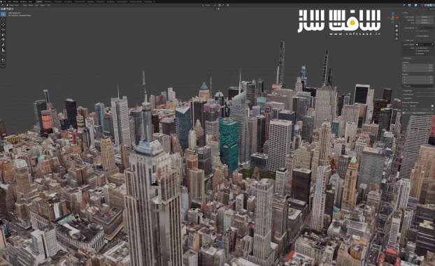
پلاگین Concept Studio OSM برای بلندر : این پلاگین تخصصی پیشرفته و قدرتمند در بستر نرمافزار بلندر با عنوان کانسپت استودیو اواسام است که مرزهای مدلسازی محیطهای شهری واقعی، جغرافیایی و بسترهای ساختمانی را دگرگون میسازد ، با استفاده از این ابزار، تنها با انتخاب یک نقطه روی نقشه تعاملی و تعیین شعاع مورد نظر، عوارض ناهمواری واقعی زمین، حجم ساختمانها، شبکه معابر و تصاویر هوایی به صورت کاملاً زمینمرجع، برشخورده دقیق در مرزهای درخواستی و هماهنگ با موقعیت نجومی واقعی خورشید وارد محیط بلندر میشوند ، با سافت ساز همراه باشید .
ویژگی های این پلاگین :
- بهرهگیری همزمان از تایلهای سهبعدی واقعگرایانه گوگل برای حجم واقعی ساختمانها و پستیبلندی بستر
- دادههای ارتفاعی توپوگرافی با وضوح 30 متر از عرض 60 درجه شمالی تا 56 درجه جنوبی بدون نیاز به حساب کاربری
- پشتیبانی از تصاویر ماهوارهای بسیار دقیق با وضوح 0.3 متر تا تصاویر بدون ابر 10 متری با انطباق مختصاتی کامل
- اتصال به دادههای شهری اوپناستریتمپ برای استخراج خیابانها، پیادهروها، پهنههای آبی و درختان بدون کلید اختصاصی
- انطباق ارتفاعی تمامی عناصر بر روی ناهمواریهای واقعی زمین به جای ارتفاع پایه در مبدا مختصات
- بازنمونهبرداری هوشمند خطوط جاده و اندازهگیری ارتفاع بر اساس کنارههای آسفالت برای عبور طبیعی از شیبها
- تثبیت لایه آب در پایینترین حد خط ساحلی و جلوگیری از معلق ماندن دریاچهها در هوا
- استخراج هندسی انواع سقفهای شیبدار، شیروانی، هرمی و تکشیب به همراه حیاطهای داخلی کاملاً توخالی
- نمای رویهای ساختمانها بر پایه مقیاس متری دقیق بدون نیاز به دانلود مگابایتها بافت حجیم
- کدگذاری رنگی کاربری ابنیه شامل بافت مسکونی، تجاری، صنعتی و اداری
- و..
Superhive Market – Concept Studio OSM — Real City Import for Blender
Pick a spot on a map. Set how far out you want to go. Get real terrain,
buildings, roads and aerial imagery inside Blender — correctly georeferenced,
cropped to the area you asked for, and lit by a sun that knows where it is.
FOUR DATA SOURCES
Google Photorealistic 3D Tiles — the same photogrammetric mesh Cesium
delivers in Unreal and D5 Render uses in its map import. Real terrain, real
building volume, real aerial photography. Uses your own free-to-start Google
Maps Platform API key.
SRTM elevation — real terrain relief at 30 m resolution, from 60°N to 56°S.
No key, no account.
Aerial imagery — Esri World Imagery down to roughly 0.3 m in cities,
Sentinel-2 cloudless at 10 m, or any tile server you already pay for. Draped
over the terrain with the projection done properly.
OpenStreetMap — buildings with pitched roofs and courtyards, roads,
sidewalks, water, green areas and mapped trees. Anywhere in the world, no API
key required. Layers directly on top of Google terrain with zero manual
alignment.
Google Open Buildings is in there too, for Africa, Latin America and
South/Southeast Asia.
IT DOESN’T STOP AT THE IMPORT
This is the part every other importer leaves to you.
Crop to the area you actually asked for — Google’s tiles always overflow it,
and the cut turns a ragged patch into a model. Flatten a pad where the project
goes, with a sloped transition to the untouched ground. Aim a sun at the real
solar position for your date and time, and keyframe a full shadow study across
your frame range in one click. Keep texture weight under control before the
render stalls. Burn the required data credits into the image.
EVERYTHING FOLLOWS THE TERRAIN
Buildings, roads, sidewalks, water and green areas are born at the ground
height, not at Z=0.
That takes more than reading the elevation at each existing vertex.
OpenStreetMap records a node only where a road turns, so a straight stretch
can run two hundred metres between them — sample only there and the road
follows the ground at both ends while cutting through the hill in the middle.
Lines and outlines are resampled first, surfaces are refined in the interior
too, and a road’s height is measured at its own edges rather than its
centreline, because a twelve-metre carriageway across a slope has metres of
difference between its uphill and downhill side.
Water stays flat, because real water is — but it sits at the lowest point of
its own bank, so a lake never floats above its shore.
BUILDINGS THAT LOOK LIKE BUILDINGS
– Pitched roofs from the OpenStreetMap tag — gabled, hipped, pyramidal,
skillion. Untagged buildings stay flat, which is most of them.
– Courtyards are real holes, not filled-in blocks.
– Procedural facades with no texture downloaded: the UVs run in real metres,
so the shader puts a floor line at every storey and a window at every
module, at the right scale on any building.
– Colour by use — residential, commercial, industrial, civic.
– Height and storey count travel as mesh attributes, so you can select or
drive Geometry Nodes by them without splitting the mesh into thousands of
objects.
QUALITY BY RING
Split your import radius into concentric zones, each with its own detail
level — maximum right at the pin, coarser as it spreads out. In testing, this
covered 2.5x the area for a fifth of the download compared to uniform maximum
detail.
BUILT FOR REAL PRODUCTION
– Pick your area on an interactive map — search an address, drop a pin, or
draw a rectangle. No copying coordinates by hand.
– Save places to a library that follows you between projects.
– Streams while it scans — geometry appears within seconds, live tile count,
MB downloaded, and a real ETA. Cancel anytime with ESC.
– Sub-centimeter georeferencing — pieces imported weeks apart still line up.
Overlapping areas never duplicate geometry.
– Materials that actually light — Google’s tiles ship “unlit” by default.
This add-on fixes it automatically, so buildings respond to your scene’s
sun, HDRI, and lights.
– No-coverage detection — warns you when an area has no 3D mesh and points
you to the OpenStreetMap fallback.
– Read coordinates back at the 3D cursor — click anywhere, get lat/lon.
این راهنمای نصب به صورت نوشته می باشد .
- فایل دانلود رو از حالت فشرده خارج کنید
- نرم افزار بلندر رو اجرا کنید و کلید ترکیبی Ctrl+Alt+U رو فشار دهید سپس Add-ons برای شما باز می شود Install from file رو انتخاب کنید
- از پوشه addons فایل Concept Studio OSM.zip رو انتخاب کنید تا در پلاگین ها فعال شود
- پلاگین نصب شد
حجم کل :
حجم فایلهای دانلودی : 1 مگابایت
دانلود پلاگین Concept Studio OSM — Real City Import for Blender
پسورد : softsaaz.ir