دانلود پروژه Landscaping برای آنریل انجین
Unreal Engine - Landscaping (5.3.0)
پروژه Landscaping برای آنریل انجین
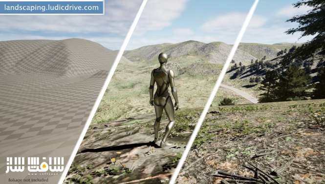
پروژه Landscaping برای آنریل انجین : این پروژه یک راه آسان برای وارد کردن دادههای GIS بهعنوان منظره، پارتیشن جهانی یا ترکیب جهانی، تولید نقشههای وزنی، پلیر Spline و موارد دیگر است ، این پروژه برای وارد کردن داده های GIS به صورت تک Landscape یا World Composition (UE4) یا World Partition (UE5) یا Procedural/Static Mesh یک راه حل ساده ارائه می دهد ، با سافت ساز همراه باشید.

عنوان : Unreal Engine – Landscaping (5.3.0)
فرمت : uasset umap
کاتالوگ : ندارد
موضوع : پروژه آنریل انجین
شرکت سازنده : Unreal Engine
Unreal Engine – Landscaping (5.3.0)
Landscaping offers an easy way to import GIS data as single Landscape or World Composition (UE4) or World Partition (UE5) or Procedural/Static Mesh.
Import Digital Terrain Models (DTM)
Supports GeoTiff, ASCII, HGT and GeoPackage file format for importing heightdata with high accuracy.
Supports all common projections and resolutions.
Imports single files or multiple files at once and automatically converts it to landscapes with appropriate tiling.
Supports automatic merging and cropping of Digital Terrain Models.
Supports smoothing of low resolution Digital Terrain Models.
Supports import DTM at a different scale.
Supports Landscapes of any area size – only limited by System Memory.
Supports Landscape Edit Layers (up to 16 x 16 km) per Landscape.
Multiple seamless Landscapes per level are possible.
Import DTM as Landscape or Mesh.
Import Satellite imagery (JPG2000/GeoTiff)
Import as Material Texture, Decal or Vertex Color (for Mesh)
Satellite imagery is automatically mapped to the Landscape / Mesh.
Import Vector Data (Shapefiles/GeoJSON/OSM/GeoPackage)
Landscaping can generate Weightmaps (auto paint landscape paint layers) and instantiate Blueprints (with or without Spline Component) or Static Mesh Spline Actors or Landscape Splines (UE5.1) from Shapefiles.
Supports automatic cropping of Shapefile data to the extent of the Landscape.
Supports deforming a Landscape and applying a paint layer under the Spline.
Readout polygons, linestrings, points and attributes via Blueprint.
No preparation of GIS data with QGIS or other tools necessary!
Technical Details
Features:
Import of Digital Terrain Models (GeoTiff, ASCII, HGT and GeoPackage files)
Import of Satellite imagery (GeoTiff and JPEG2000 files)
Import of Vector Data (Shapefiles, GeoJSON, OSM, GeoPackage files)
Automation of Procedural Foliage Spawner
Road Assets
حجم کل : 174 مگابایت

برای دسترسی به کل محتویات سایت عضو ویژه سایت شوید
برای نمایش این مطلب و دسترسی به هزاران مطالب آموزشی نسبت به تهیه اکانت ویژه از لینک زیر اقدام کنید .
دریافت اشتراک ویژه
مزیت های عضویت ویژه :
- دسترسی به همه مطالب سافت ساز بدون هیچ گونه محدودیتی
- آپدیت روزانه مطالب سایت از بهترین سایت های سی جی
- بدون تبلیغ ! بله با تهیه اکانت ویژه دیگه خبری از تبلیغ نیست
- دسترسی به آموزش نصب کامل پلاگین ها و نرم افزار ها
اگر در تهیه اشتراک ویژه مشکل دارید میتونید از این لینک راهنمایی تهیه اشتراک ویژه رو مطالعه کنید . لینک راهنما
For International user, You can also stay connected with online support. email : info@softsaaz.ir telegram : @SoftSaaz
امتیاز دهی به این مطلب :
امتیاز
لطفا به این مطلب امتیاز دهید